This is not a "blog" in the sense of a daily journal but a place for me to post GPS trail maps of mountain biking and hiking trails, particularly but not exclusively, in the western Greenbelt in Ottawa, Ontario.

Hybrid & E-Bikeable Routes and National Capital Region Cycling Routes and Resources are also included on this site,

Date codes do not reflect actual posting dates but are manipulated to allow me to order the posts in a thematic order.

19901125

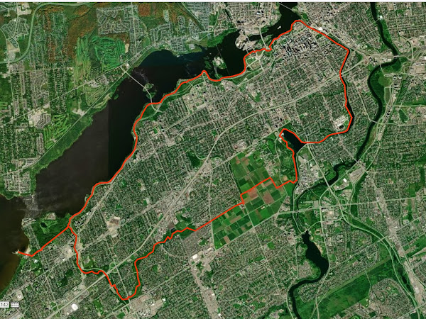
Britannia, Ottawa River, Rideau Canal, Experimental Farm, Pinecrest Creek Pathways Hybrid & E-Bikeable Route

This 33.8 km loop, which follows the Ottawa River, Eastern Rideau Canal, Experimental Farm and Pinecrest Creek pathways can be combined with the Bridlewood to Britannia 37.7 km loop for a longer loop of 71.5 km.

The Maps
(Double Click to Enlarge Full Size)

The Route

PRELIMINARY NOTE: This reads more complicated than it is. Once you are on the route it is quite intuitive.

Starting at the pier at Britannia Park you follow the Ottawa River Pathway past Westboro Beach, the Chief William Commanda Bridge, and the National War Museum. Be sure to follow the solid yellow lines as you go under the Ottawa River Parkway and Wellington Street and then continue past the Parliament Buildings (up above) to the Rideau Canal.

At the canal you will have a granny gear ride up the hill. After you go under Wellington Street you will have two staircases to walk your bike down along a wheel ramp provided along the side of the steps. After you pass the National Arts Centre keep your eye open for the path on the right that takes you up to the Rideau Canal Eastern Pathway. Follow the pathway to Dow’s Lake where you go behind Canadian Forces Reserve Barrack Dow's Lake (HMCS Carleton) and continue to the next set of locks across from Carleton University.

At the locks go right and follow the road across Prince of Wales Drive onto the Experimental Farm. Turn right at Morningside Lane and left at Cow Lane and continue along the Experimental Farm Pathway. When you get to Fisher Avenue you have to go right a short bit till you continue along the Experimental Farm Pathway on the left. You will have a long (but not steep) annoying climb till you get to Merivale Road and then there will be a relatively steep downhill just before Maitland Avenue.

After you cross Woodroffe Avenue by the fire station you join the Pinecrest Creek Pathway. Follow the pathway till you get to Iris Street and cross over to the left side of the transitway and continue along the Pinecrest Creek Pathway till you join the Ottawa River Pathway and go left back to Britannia.

Hopefully you will have had an enjoyable ride.

Altitude Profile
Slide Show

   
Viewing Slide Show Full Screen Recommended

GPS gpx Files

The gpx file for this route (and other routes and trail systems) can be downloaded by clicking the link below:

GPX files - Google Docs

If you do download the gpx file please email me at richardw.woodley@gmail.com and let me know so that I have an idea of how many people are downloading and using the files.

Posted 2021-07-31

19900105

Beyond Richard's GPS Trail Maps – Open Street Map and GPS Visualizer

When I fist started mountain biking one of the first things I noticed was the number of unofficial trails in the Greenbelt not on the NCC maps, or other maps that I was aware of. So I decided to make it a project to map all of the NCC trails in the Greenbelt, including those not on the NCC maps. I never did get beyond the western Greenbelt because there were enough places there to ride without heading to the far east of the city. However I did end up adding some trail systems not part of NCC lands. One commercial map source even requested to use my maps in their products, to which I agreed in exchange for a copy of the map my trail maps were included in.

Now that I have retired from mountain biking I will not be updating these maps anymore (although I intend to expand on the E-Bikeable routes section of this site). I hope people will still find value in the trail descriptions and slide shows that are not available elsewhere.

Fortunately there are now many free options for trail maps of the Greenbelt and other areas. One of the best is the “community driven” Open Street Map project. Despite it’s name it has excellent trail coverage. Their coverage of the Old Quarry Trail System, which I am most familiar with, is excellent.

There are a number of sites where one can download maps based on Open Street Map data. The one I find the most convenient and easiest to use to download maps to load on my Garmin GPS and to install on my computer for use with BaseCamp or MapSource is Open Map Chest. You can download the Open Map Chest Canada map here.

I also discovered another map site, 4Umaps, that looks like it may be interesting, but more complicated. It may be worth examining further.

For those that like to create maps of the tracks of their rides or hikes to share, using the gpx or gdb files, there is an excellent web site, GPS Visualizer, that allows you to do this. It uses a number of different background maps, some based on Open Street Map, and includes topographical and relief maps and satellite imagery. I usually go directly here to create my GPS visualizer maps and then take a screenshot of the results.

 Open Map Chest Canada Sample Map Showing Track of a Ride


GPS Visualizer Sample Maps (not all options are shown) Showing Track of a Ride

ArcGIS Hybrid


ArcGIS Street Map


Canada Toporama

Open Street Map


OSM 4UMaps

OSM Topo


Posted:2023-10-08


Labels

Followers

About Me

My photo
Richard W. Woodley was born in Sudbury, Ontario in 1950. He earned an Honours Bachelor of Arts in Political Science from Laurentian University where he was the News Editor of the student newspaper Lambda and active in student politics. He was active in the New Democratic Party and Waffle in Sudbury and Kanata, as well as Kanata municipal politics. He was a member of the Bridlewood Residents Hydro Line Committee (BRHLC) and creator of the now archived Bridlewood Electromagnetic Fields (EMFs) Information Service. He worked on Parliament Hill for 33 years indexing the Debates of the House of Commons (Hansard) and it's committees. Richard has been an outdoorsperson and environmentalist for most of his life and a life long cyclist who also mountain bikes.