This is not a "blog" in the sense of a daily journal but a place for me to post GPS trail maps of mountain biking and hiking trails, particularly but not exclusively, in the western Greenbelt in Ottawa, Ontario.

Hybrid & E-Bikeable Routes and National Capital Region Cycling Routes and Resources are also included on this site,

Date codes do not reflect actual posting dates but are manipulated to allow me to order the posts in a thematic order.

Showing posts with label Stittsville. Show all posts

20001010

Stittsville Trail System

These are the trails that were hiding right in front of my eyes as I biked past them on my hybrid always wondering where they led to. Finally I decided to check them out and this is the result.


Stittsville is a suburb, that used to be a village, on the southwest edge of Ottawa's urban boundary. These trails lead off of a pathway/trail that goes from the Trans-Canada Trail to Hazeldean Road and runs behind the houses along the urban boundary.

This is not an official trail system and no official parking lot exists. I parked along the road at the end of Thresher Avenue, but there are parking lots serving businesses along Hazeldean Road, including the shopping centre at Jackson Trails, that are close enough to ride from.

The southern section of trails includes sections that go over open grasslands and are not that interesting but, as anyone who has rode on grass will know, can be hard pedaling. The most interesting trails go into the forest where some sections are marked with coloured ribbons. However, most of the trails do not have any ribbons or markings.

At the northern end of the trail system are a couple of trails that go into areas where there are wooden structures and large 4X8 wood sheets. These look like they may be set up for paint ballers to hide behind except that there are no signs of spilled paint, so maybe they are just play forts.

In the middle section is a long trail heading towards Hazeldean Road which deteriorates until it is no longer a trail but just deer tracks in the middle of dense bush.

There are some really interesting features within this system, including a trail that runs along a creek, and a real interesting causeway/bridge over the creek with another alternative narrower more technical/difficult bridge a few feet further along.

There are quite a few sections where trees are lying across the trails and tree branches are growing into the trails. There are also some wet/muddy sections that could do with some trail work.
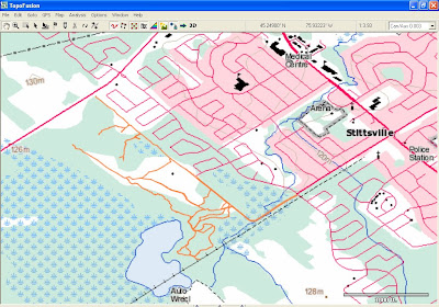

This land is outside the urban boundary of Ottawa and from what I can tell from the Ottawa Zoning Map is partly zoned RU (Rural Countryside) and partly EP3 (Environmental Protection). I do not know who owns the land but there is certainly potential for a really fun greenbelt-like trail system here with a little/lot of work.

GPS gpx Files

The gpx file for this trail system (and other trail systems) can be downloaded by clicking the link below:

GPX files - Google Docs

If you do download the gpx file please email me at richardw.woodley@gmail.com and let me know so that I have an idea of how many people are downloading and using the files.

Photos From Stittsville Trail System


Posted 2009-06-05
Updated 2011-10-04

20001005

Stittsville “Jackson Trails” Trail System

I first noticed these trails when I was riding the urban paths in the area and saw a “lane” indicated on the Backroad Mapbooks map on my GPS. I looked closer and decided to check it out on my mountain bike and discovered a whole unmapped trail system back there.

Map note: The urban paths, indicated in blue on the map, are not included with GPX file except for the link connecting the red trails together.

The first thing I noticed was that these trails appear to be well maintained, about the width of a vehicle and apparently kept cleared by some kind of mowing equipment. Most of them are hard packed grass trails, with some gravel/dirt/rock sections, but because they are hard packed they are easier to ride on than most grass trails.

There are essentially two types of vegetation in this system which you can see on the Google Earth view in the background of the map. Where the Main Trails are are smaller trees, brush and bushes and tall grasses, while the area to the northeast where the Forest Trail is is denser bush. This trail is different also, not being packed grass but more like a very primitive cottage or fire road that appears to be abandoned, although it ends next to a cornfield.

The Forest Trail is the most interesting and natural trail as you can see from the photos. That area of dense forest is unfortunately zoned Development Reserve.

Map note: You will notice that the trail running northwest from the pond turns ninety degrees southwest, however it also continues straight but becomes very overgrown. It is what would be called a “cart track” on old topo maps, but appears more like a rarely used ATV trail. It ends at the marker just before Highway 417. That part is not on the GPX file.

The area where the Main Trails are is zoned Rural Countryside.

Map note: You will notice the “Homestead” marker on the map, which is where the remnants of an old homestead can be seen (see photos). There is another remnant of an old homestead next to the “Main Trails” label on the map at the intersection.

Map note: You will notice a “Bridge” marker along the back trail running southwest. At that point there is a creek with a very nice new wooden bridge set up to go across it but not put in place yet. The other side of the bridge appears to be a very overgrown trail which likely leads to the trail passing by the homestead where the well maintained well defined trail also appears to become a very overgrown trail that I did not follow and so is not on the GPX file.

Map note: The southwestern end of the trail that goes by the bridge ends at a farm but it is possible, but not recommended except in an emergency, to follow another overgrown trail to the inside of the farmer's gate where there is a cement barricade that it is possible to lift your bike over, but you would be clearly trespassing if you did that.

Map note: You will also notice a section of trail marked “Field”. I only included this because of it's proximity to the other trails. It is similar in being a maintained trail clearly indicated by having it's path mowed through a grassy field.

I really have no idea what these trails are for although they are well maintained but appear to be unofficial. My best guess is that they are ATV/snowmobile trails, although the few times I have been there I have only seen dog walkers on them. They do make a great unofficial off leash dog area. The old homesteads are kind of neat to see and the Forest Trail is really nice.

GPS gpx Files

The gpx file for this trail system (and other trail systems) can be downloaded by clicking the link below:

GPX files - Google Docs

If you do download the gpx file please email me at richardw.woodley@gmail.com and let me know so that I have an idea of how many people are downloading and using the files.

Photos of Main Trails

Photos of Old Homestead

Photos of Forest Trail

Posted 2013-10-08

Labels

Followers

About Me

My photo
Richard W. Woodley was born in Sudbury, Ontario in 1950. He earned an Honours Bachelor of Arts in Political Science from Laurentian University where he was the News Editor of the student newspaper Lambda and active in student politics. He was active in the New Democratic Party and Waffle in Sudbury and Kanata, as well as Kanata municipal politics. He was a member of the Bridlewood Residents Hydro Line Committee (BRHLC) and creator of the now archived Bridlewood Electromagnetic Fields (EMFs) Information Service. He worked on Parliament Hill for 33 years indexing the Debates of the House of Commons (Hansard) and it's committees. Richard has been an outdoorsperson and environmentalist for most of his life and a life long cyclist.