This is not a "blog" in the sense of a daily journal but a place for me to post GPS trail maps of mountain biking and hiking trails, particularly but not exclusively, in the western Greenbelt in Ottawa, Ontario.

Hybrid & E-Bikeable Routes and National Capital Region Cycling Routes and Resources are also included on this site,

Date codes do not reflect actual posting dates but are manipulated to allow me to order the posts in a thematic order.

Showing posts with label KNL. Show all posts

20000930

South March Highlands Trails

This website was originally intended to just include maps of the Greenbelt trails within Ottawa but as I rode other trails I decided to include them as well, including the South March Highlands (SMH) trails.

Since before the creation of the City of Kanata in 1978 there have been concerns raised about the proposed development of Ottawa’s most bio-diverse natural area, the South March Highlands. We will look at these concerns at the end of this post.

(click on all maps to enlarge images)

 The South March Highlands is home to the most natural and technical mountain biking trails within the City of Ottawa that are considered to be amongst the ten best mountain biking trails in Canada. The extensive trail network includes trails on city-owned land as well as trails on private land slated for development. The Ottawa Mountain Bike Association (OMBA) maintains a sustainable trail network within the City-owned South March Highlands Conservation Forest, for which the City is now developing a management plan.

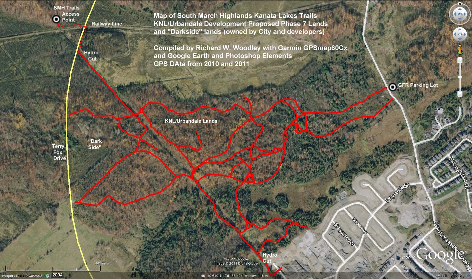
My comments, concerns and submissions about the South March Highlands Conservation Forest Management Plan can be read on my blog,The Fifth Column.

Historical Maps of the South March Highlands/Kanata Lakes Trails


 Latest OMBA Map 2013


More detailed maps of the different parts of the SMH trail system follow this post.

GPS gpx Files

The gpx file for this trail system (and other trail systems) can be downloaded by clicking the link below:

GPX files - Google Docs

If you do download the gpx file please email me at richardw.woodley@gmail.com and let me know so that I have an idea of how many people are downloading and using the files.

South March Highlands (SMH) Development Proposals


The Map below puts these trails within the context of the rest of the South March Highlands and the destruction planned for it.


The key things to know about the South March Highlands are:

• it is a popular all year recreation destination for people from all over Ottawa and an international mountain biking destination

• while, within the City of Ottawa, it feels like wilderness when you are in it

• it is a candidate Area of Natural and Scientific Interest (ANSI)

• it is the most biodiverse area within Ottawa

• it is the home to a huge number of species of flora and fauna, including many endangered and threatened species

• it contains old growth forests and provincially significant wetlands

• it includes Canadian Shield geology and other significant geological features

• it is the site of numerous pre-contact (pre-European) archaeological sites and may be eligible for UN World Heritage Site status

• it has been declared sacred by Algonquin First Nations chiefs and elders

• the area considered the most environmentally significant, Trillium Woods, is under great ecological threat because KNL's development plans will cut it off from the rest of the city-owned Conservation Forest

• while the privately owned land north of the city-owned Conservation Forest is zoned Environmental Protection, that has been proven not to be enough to protect the land from the threat of development
But the most important thing that you need to know about the South March Highlands is that it is one ecosystem and harm to one part of it harms all of it and if you want to protect part of it you must protect all of it.

You can read my concerns about the development of the South March Highlands on my blog, The Fifth Column.

Posted 2011-09-02
Updated 2017-10-30

20000920

South March Highlands Kanata Lakes Trails

These are the trails that I first tried serious mountain biking on. Indeed the first time I tried them on my old CCM I turned around and rode the gravel paths on the parking lot side of the road. But that did inspire me to invest in a proper entry level full suspension mountain bike and venture to join an MTB Kanata group ride. But after being left in the dust I turned around and rode the easy trails again, only to find out later that the other riders had been waiting for me further up the trail. After a few MTB Kanata group rides in the Greenbelt I ventured out with the group again on the KL trails and have been riding them and the trails in the SMH Conservation Forest ever since.

Please click on the maps posted below to enlarge the images


The trails referred to as the Kanata Lakes Trails are the trails in the South March Highlands that are southeast of the Conservation Forest Trails that the Ottawa Mountain Bike Association group rides are held on (between Goulbourn Forced Road and the new Terry Fox Drive Extension). These are primarily on the KNL Urbandale lands (Phase 7) that are slated for destruction. The trails mapped also include some trails in what was called the "dark side" where the landowners had posted No Trespassing signs and fenced off the land. These trails now seem to all be accessible again, at least some of the land having been purchased by the City, the rest owned by developers and slated for destruction.

I started mapping these trails in May this year and wrote about it on my blog The Fifth Column.

Most of these trails were originally nature trails and cross-country ski trails as the old City of Kanata Map below (date unknown) indicates.


GPS gpx Files

The gpx file for this trail system (and other trail systems) can be downloaded by clicking the link below:

GPX files - Google Docs

If you do download the gpx file please email me at richardw.woodley@gmail.com and let me know so that I have an idea of how many people are downloading and using the files.

Posted 2011-08-16
Updated 2011-10-04

Labels

Followers

About Me

My photo
Richard W. Woodley was born in Sudbury, Ontario in 1950. He earned an Honours Bachelor of Arts in Political Science from Laurentian University where he was the News Editor of the student newspaper Lambda and active in student politics. He was active in the New Democratic Party and Waffle in Sudbury and Kanata, as well as Kanata municipal politics. He was a member of the Bridlewood Residents Hydro Line Committee (BRHLC) and creator of the now archived Bridlewood Electromagnetic Fields (EMFs) Information Service. He worked on Parliament Hill for 33 years indexing the Debates of the House of Commons (Hansard) and it's committees. Richard has been an outdoorsperson and environmentalist for most of his life and a life long cyclist who also mountain bikes.